Most Popular Caney Fork River Access Points
Below are the Caney Fork River Access Points we service on The Caney Fork River. Please be aware that as the river changes, the water may be higher or lower than depicted in these images. Be sure to check the generator schedule and water flow before your river paddle.
Long Branch Recreation Area
Long Branch Rec Area is a boat ramp and campground located at the base of Center Hill Dam. This is the only option when it comes to staying the night on the river since the majority of the Caney Fork is private property. This location has a large parking area and a full bathroom and is seen as an excellent launch location.
Address: 478 Lancaster Rd, Lancaster, TN 38569
Popular Trips From Here:
Happy Hollow: 1.5-3 hour float, passing by sprawling cow fields and tall trees.
Bettys Island: 3-5 hour float, taking you under the historic “Green Mile” train bridge, tall cliffs, and the many interstate ramps.
Buffalo Valley Recreation Area

Opposite Long Branch at the base of Center Hill Dam is Buffalo Valley Boat Ramp. This is the base of operations for the local Army Corps, fit with a public restroom and large parking area.
Address: 143 Resource Lane, Lancaster, TN 38569 (this is the entrance building, continue past this to the ramp)
Popular Trips From Here:
Happy Hollow: 1.5-3 hour float, passing by sprawling cow fields and tall trees.
Bettys Island: 3-5 hour float, taking you under the historic “Green Mile” train bridge, tall cliffs, and the many interstate ramps.
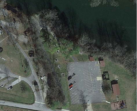
Happy Hollow Boat Ramp
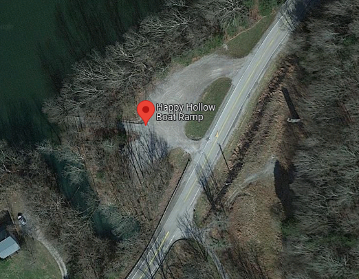
Happy Hollow Boat Ramp is one of if not THE most popular Caney Fork River access points. Located the perfect distance from the dam to use as a pickup location, from Bettys island for a short float, or from Stone Wall for a longer day float. It is also just a few minutes off of I-40 making it very accessible. Be wary on a busy weekend though as the parking lot is very small and fills up quickly.
Address: 5238 Medley Amonette Rd, Buffalo Valley, TN 38548
Popular Trips:
Start at Long Branch: 1.5-3 hour float, passing by sprawling cow fields and tall trees.
End at Stone Wall: 3-5 hour float, starts by passing under the “Green Mile” train bridge and the multiple interstate overpasses then take a long stretch through scenic woods.
Bettys Island Boat Ramp

Bettys Island Boat Ramp is a popular location for paddlers and for anyone wanting to try their luck with some trout fishing. Known for it’s famous “Island” when the water is lower, it is very easy to walk out into the middle of the river to cast for trout. Bettys Island also features a smaller parking lot that fills up quickly as well as a very long and narrow road from the parking lot to the water. Prepare for potential long waits and backups as cars take their turns.
Address: Stonewall Club Springs Rd, Buffalo Valley, TN 38548
Popular Trips:
Start at Dam: 3-5 hour float, follows along a scenic stretch of woods and fields and ends after the “Green Mile” bridge.
End at Stonewall: 2-5 hour float, winds under the overpasses and goes along a scenic stretch of greenery.
Stone Wall Boat Ramp
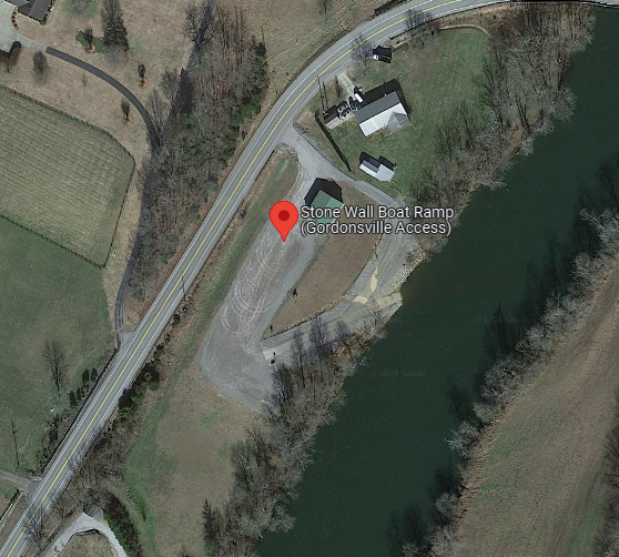
Stone Wall Boat Ramp is one of the larger access points with a loop ramp for easy backing to the water and a massive parking lot with a field for overflow parking. This Caney Fork River access point has been slowly gaining popularity as one of the best ramps for a take-out location.
Address: 14 Trousdale Ferry Pike, Gordonsville, TN 38563
Popular Trips From Here:
Start at Bettys Island: 2-5 hour float, winds under the overpasses and goes along a scenic stretch of greenery.
End at South Carthage: 3-5 hour float, winds through scenic landscapes
South Carthage Ag Center

South Carthage Boat Ramp is the main ramp used for those close to Carthage, and is becoming more popular to those coming from Nashville as it is located further west than any options before it. This ramp features a decently sized parking lot with over flow parking lots close by.
Address: South Carthage, TN 37030
Popular Trips:
Start at Stone Wall: 3-5 hour float, winds through scenic landscapes
End at Carthage Lighthouse: 2-4 hour float, take a long turn through scenic Carthage
Carthage Light House

The Carthage Light House is one of the least used Caney Fork River access points. Located where the Caney joins the Cumberland, the waterflow can vary greatly depending on the waterflow from both rivers. Be wary to paddle hard to the ramp to not get pulled along with the bigger Cumberland Rivers water flow.
Address: 104 Eatherly Landing Rd, Carthage, TN 37030
Popular Trips:
From South Carthage Ag Center: 2-4 hour float, take a long turn through scenic Carthage
Book a trip to your favorite Caney Fork destination points HERE today!