
Directions for the Caney Fork River
Navigating the Caney Fork River might appear challenging at first, but fear not! Numerous resources are available to assist you on your journey. All river access points feature well-maintained roads and offer free designated parking areas for public use. For a comprehensive list of access points and driving directions, visit our dedicated page Here. Once on the water, rely on the well-maintained public river map and the featured Canoe the Caneys app, available on both Apple and Android platforms, complete with GPS directions for seamless navigation.
Caney Fork River App
The Caney Fork River app serves as your ultimate companion for everything you need while on the river.

- Featuring GPS tracking and turn-by-turn directions, you can confidently navigate your paddle down the river. For added assurance, we’ve included a picture of the classic river map within the app. Never worry about getting lost again!
- Invaluable information such as water and weather conditions, ensuring you’re always well-prepared. Say goodbye to wasted trips due to high waters or approaching storms.
- Discover all the different river access points, complete with directions, trip possibilities, and facility details.
- But that’s not all! Dive into a wealth of fun facts about local wildlife, fauna, fishing spots, historical tidbits, and notable landmarks like the famous Green Mile Bridge and the Carthage Lighthouse.
- Best of all, we’ve designed the app to be user-friendly and completely free for all paddlers, not just our customers. So why wait? Download our app now and embark on your river adventure today!
Downloads for Android and for iPhone available.
Caney Fork River Map
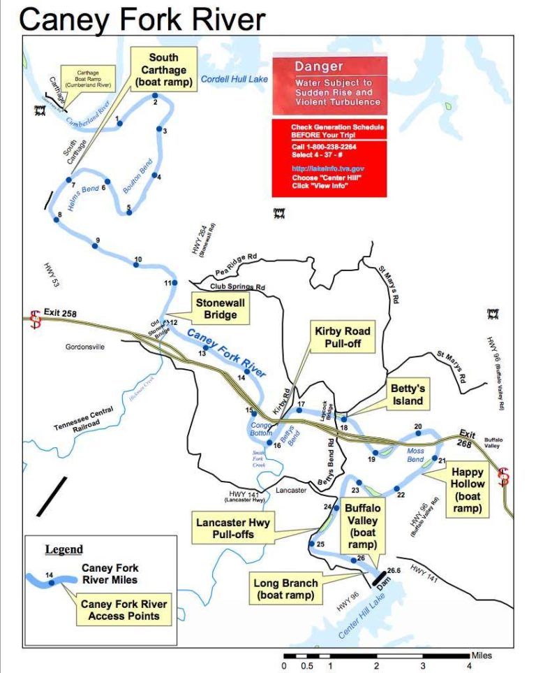
The Caney Fork River map is well maintained and has markings showing river mile markers, close by roads, landmarks along the river, and all the access points available while paddling. The Caney Fork River map shows all seven of the main ramps along the river in clear labeled boxes making it easy to decide the best options for put in and take out during your paddle trip. Or swing by Canoe the Caney and we will choose the best option for the day and eliminate any hassle by taking you to and from the river.
If you have additional questions, please don’t hesitate to give us a call. We will be more than happy to tell you all about it! You can also follow this link for a more detailed map of the Caney Fork River.