We Are Open for Trips Today
Caney Fork River
The Caney Fork River is a beautiful attraction, serving up the best Tennessee has to offer. With the cool, clear water, the river allows guests to enjoy all its beauty with each passing season. The changing beauty of Middle Tennessee in Spring, Summer, Winter and Fall each offer their own unique experience. And the Caney Fork River Map is a necessary part in guiding you along your river float!
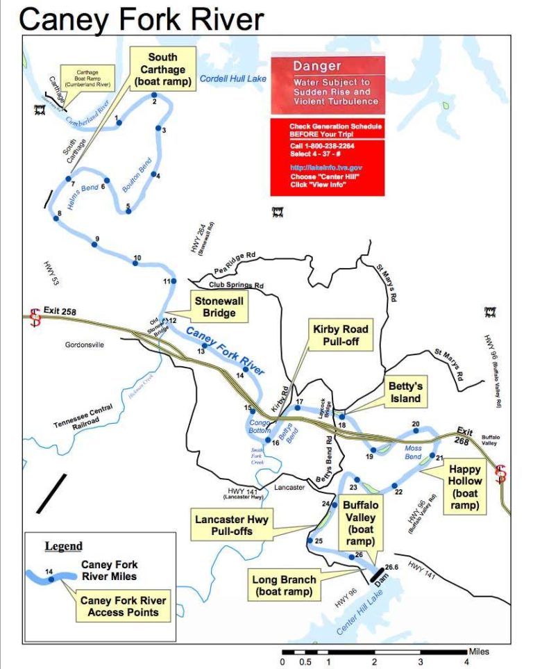
The Caney Fork River map is well maintained and has markings showing river mile markers, close by roads, landmarks along the river, and all the access points available while paddling. The Caney Fork River map shows all seven of the main ramps along the river in clear labeled boxes making it easy to decide the best options for put in and take out during your paddle trip. Or swing by Canoe the Caney and we will choose the best option for the day and eliminate any hassle by taking you to and from the river. If you have additional questions, please don’t hesitate to give us a call. We will be more than happy to tell you all about it! You can also follow this link for a more detailed map of the Caney Fork River.
Caney Fork River App

For an even easier option than the Caney Fork River Map, check out our Canoe the Caney River APP! We designed an App for Android or iPhone that gives you general information about anything you may want to know about the river. Most importantly though is the trip chooser and GPS guidance, showing you turn-by-turn directions while on the river. Never get lost with this free to use App, available to anyone, even if you are not paddling with us.
River Map Key Destinations
Don’t get confused while looking at the Caney Fork River map. There may seem like too many river access points to make a decision so we will break down the locations in order to help you decide. Check out our full Access Point breakdown on the official page. List of locations in order as they appear from the dam below:


Great Family Fun, all Season Long. Limited Availability!

Our Location
Directions
1 Mile Off I-40 Exit 273
17055 Smithville Hwy Silver Point, TN 38582 USA 1-800-579-7893